
Exhibit 96.3
TECHNICAL REPORT SUMMARY
COAL RESOURCES
MASON DIXON AND RIVER MINE PROPERTIES
Greene County, Pennsylvania
Marshall, Monongalia, and Wetzel Counties, West Virginia
Prepared For
CONSOL ENERGY INC.
By
John T. Boyd Company
Mining and Geological Consultants
Pittsburgh, Pennsylvania, USA
Report No. 2755.084
FEBRUARY 2022
|
|
John T. Boyd Company |
|
Chairman James W. Boyd
President and CEO John T. Boyd II
Managing Director and COO Ronald L. Lewis
Vice Presidents Robert J. Farmer Matthew E. Robb John L. Weiss Michael F. Wick William P. Wolf
Managing Director - Australia George Cumplido
Managing Director - China Jisheng (Jason) Han
Managing Director – South America Carlos F. Barrera
Managing Director – Metals Gregory B. Sparks
Pittsburgh 4000 Town Center Boulevard, Suite 300 Canonsburg, PA 15317 (724) 873-4400 (724) 873-4401 Fax jtboydp@jtboyd.com
Denver (303) 293-8988 jtboydd@jtboyd.com
Brisbane 61 7 3232-5000 jtboydau@jtboyd.com
Beijing 86 10 6500-5854 jtboydcn@jtboyd.com
Bogota +57-3115382113 jtboydcol@jtboyd.com
www.jtboyd.com |
February 4, 2022 File: 2755.084
CONSOL Energy Inc. 1000 CONSOL Energy Drive, Suite 100 Canonsburg, PA 15317-6506
Attention: Mr. Michael Bohan Senior Geologist
Subject: Technical Report Summary Coal Resources Mason Dixon and River Mine Properties Greene County, Pennsylvania Marshall, Monongalia, and Wetzel Counties, West Virginia
Ladies and Gentlemen:
The John T. Boyd Company (BOYD) was retained by CONSOL Energy Inc. (CONSOL) to complete an independent technical assessment of the coal resource estimates for the Mason Dixon and River Mine Properties as of December 31, 2021.
This technical report summary: 1) identifies and summarizes the scientific and technical information supporting the coal resource estimates for the Mason Dixon and River Mine Properties and 2) provides BOYD’s conclusions resulting from our independent assessment.
Respectfully submitted,
JOHN T. BOYD COMPANY
By:  John T. Boyd II President and CEO |
TABLE OF CONTENTS
| Page | ||||
| LETTER OF TRANSMITTAL | ||||
| TABLE OF CONTENTS | ||||
| DISCLAIMERS AND QUALIFICATIONS | ||||
| GLOSSARY AND ABBREVIATIONS | ||||
|
1.0 |
EXECUTIVE SUMMARY |
1-1 |
||
|
1.1 |
Introduction |
1-1 |
||
|
1.2 |
Property Description |
1-1 |
||
|
1.3 |
Geology |
1-3 |
||
|
1.4 |
Exploration |
1-3 |
||
|
1.5 |
Coal Resources/Reserves |
1-4 |
||
|
1.6 |
Conclusions |
1-5 |
||
|
2.0 |
INTRODUCTION |
2-1 |
||
|
2.1 |
Registrant and Purpose |
2-1 |
||
|
2.2 |
Terms of Reference |
2-1 |
||
|
2.3 |
Expert Qualifications |
2-2 |
||
|
2.4 |
Principal Sources of Information |
2-3 |
||
|
2.5 |
Personal Inspections |
2-3 |
||
|
2.6 |
Effective Date |
2-3 |
||
|
2.7 |
Units of Measure |
2-4 |
||
|
3.0 |
PROPERTY OVERVIEW |
3-1 |
||
|
3.1 |
Property Location |
3-1 |
||
|
3.2 |
Property Control |
3-1 |
||
|
3.2.1 Coal Ownership |
3-3 |
|||
|
3.2.2 Surface Ownership |
3-3 |
|||
|
3.3 |
Regulation and Liabilities |
3-3 |
||
|
4.0 |
PHYSIOGRAPHY, ACCESSIBILITY, AND INFRASTRUCTURE |
4-1 |
||
|
4.1 |
Topography, Elevation, and Vegetation |
4-1 |
||
|
4.2 |
Accessibility |
4-1 |
||
|
4.3 |
Climate |
4-1 |
||
|
4.4 |
Infrastructure |
4-2 |
||
|
5.0 |
HISTORY |
5-1 |
||
TABLE OF CONTENTS - Continued
| Page | ||||
|
6.0 |
GEOLOGY |
6-1 |
||
|
6.1 |
Regional Geology |
6-1 |
||
|
6.2 |
Local Stratigraphy |
6-2 |
||
|
6.2.1 |
Conemaugh Group |
6-3 |
||
|
6.2.2 |
Monongahela Group |
6-3 |
||
|
6.2.3 |
Dunkard Group |
6-3 |
||
|
6.3 |
Coal Seam Geology |
6-3 | ||
|
6.3.1 |
Lithology |
6-3 |
||
|
6.3.2 |
Structure |
6-6 |
||
|
6.3.3 |
Coal Quality |
6-7 |
||
|
7.0 |
EXPLORATION DATA |
7-1 |
||
|
7.1 |
Background |
7-1 |
||
|
7.2 |
Procedures |
7-1 |
||
|
7.2.1 |
Drilling |
7-1 |
||
|
7.2.2 |
Coal Quality Sampling |
7-2 |
||
|
7.2.3 |
Coal Washability Testing |
7-4 |
||
|
7.2.4 |
Other Exploration Methods |
7-4 |
||
|
7.3 |
Results |
7-4 |
||
|
7.3.1 |
Summary of Exploration |
7-4 |
||
|
7.3.2 |
Adequacy of Exploration |
7-4 |
||
|
7.4 |
Data Verification |
7-6 |
||
|
8.0 |
SAMPLE PREPARATION, ANALYSIS, AND SECURITY |
8-1 |
||
|
9.0 |
DATA VERIFICATION |
9-1 |
||
|
10.0 |
MINERAL PROCESSING AND METALLURGICAL TESTING |
10-1 |
||
|
11.0 |
COAL RESOURCE ESTIMATE |
11-1 |
||
|
11.1 |
Applicable Standards and Definitions |
11-1 |
||
|
11.2 |
Coal Resources |
11-2 |
||
|
11.2.1 |
Methodology |
11-2 |
||
|
11.2.2 |
Criteria |
11-3 |
||
|
11.2.3 |
Classification |
11-4 |
||
|
11.2.4 |
Coal Resource Estimate |
11-6 |
||
|
12.0 |
COAL RESERVE ESTIMATE |
12-1 |
||
|
12.1 |
Coal Reserves |
12-1 |
||
TABLE OF CONTENTS - Continued
| Page | ||||
|
13.0 |
MINING METHODS |
13-1 |
||
|
14.0 |
PROCESSING OPERATIONS |
14-1 |
||
|
15.0 |
MINE INFRASTRUCTURE |
15-1 |
||
|
16.0 |
MARKET STUDIES |
16-1 |
||
|
17.0 |
PERMITTING AND COMPLIANCE |
17-1 |
||
|
17.1 |
Permitting |
17-1 |
||
|
17.2 |
Compliance |
17-1 |
||
|
17.3 |
Socio-Economic Impact |
17-2 |
||
|
18.0 |
CAPITAL AND OPERATING COSTS |
18-1 |
||
|
19.0 |
ECONOMIC ANALYSIS |
19-1 |
||
|
20.0 |
ADJACENT PROPERTIES |
20-1 |
||
|
21.0 |
OTHER RELEVANT DATA AND INFORMATION |
21-1 |
||
|
22.0 |
INTERPRETATION AND CONCLUSIONS |
22-1 |
||
|
22.1 |
Audit Findings |
22-1 |
||
|
22.2 |
Significant Risks and Uncertainties |
22-1 |
||
|
23.0 |
RECOMMENDATIONS |
23-1 |
||
|
24.0 |
REFERENCES |
24-1 |
||
|
25.0 |
RELIANCE ON INFORMATION PROVIDED BY REGISTRANT |
25-1 |
||
TABLE OF CONTENTS - Continued
| Page | ||
|
List of Tables |
||
|
1.1 |
Coal Resources Summary |
1-4 |
|
3.1 |
Summary of Pittsburgh Seam Coal Ownership |
3-3 |
|
4.1 |
Monthly Average Climate Data, Morgantown Municipal Airport, WV |
4-2 |
|
5.1 |
Historical Pittsburgh Seam Production |
5-1 |
|
7.1 |
Descriptive Statistics, Pittsburgh Seam Thickness |
7-6 |
|
7.2 |
Descriptive Statistics, Pittsburgh Seam Quality Analyses |
7-6 |
|
11.1 |
Mining and Processing Parameters |
11-4 |
|
11.2 |
Coal Resource Classification Criteria |
11-6 |
|
11.3 |
Estimated Coal Resources |
11-8 |
|
11.4 |
Coal Resources Summary |
11-6 |
|
11.5 |
Estimated Coal Product Quality Summary |
11-9 |
|
List of Figures |
||
|
1.1: |
General Location Map |
1-2 |
|
3.1: |
Map Showing General Layout and Project Boundary |
3-2 |
|
6.1: |
Generalized Stratigraphic Chart, Southwestern Pennsylvania |
6-2 |
|
6.2 |
Generalized Stratigraphic Section |
6-4 |
|
6.3 |
Map Showing Pittsburgh Seam Isopachs |
6-5 |
|
7.1 |
Map Showing Drill Hole Locations |
7-5 |
|
11.1 |
Relationship Between Coal Resources and Coal Reserves |
11-2 |
|
11.2 |
Map Showing Clean Coal Yield Isopleths, Pittsburgh Seam |
11-5 |
|
11.3 |
Map Showing Resource Area, Pittsburgh Seam |
11-7 |
|
11.4 |
Map Showing Clean Coal Ash Isopleths, Pittsburgh Seam |
11-10 |
|
11.5 |
Map Showing Clean Coal Sulfur Isopleths, Pittsburgh Seam |
11-11 |
DISCLAIMERS AND QUALIFICATIONS
This report is intended for use by CONSOL subject to the terms and conditions of its professional services agreement with BOYD. The agreement permits CONSOL to file this report as a technical report summary with the U.S. Securities and Exchange Commission (SEC) pursuant to Subpart 1300 and Item 601(b)(96) of Regulation S-K. Except for the purposes legislated under US securities law, any other uses of or reliance on this report by any third party is at that party’s sole risk. The responsibility for this disclosure remains with CONSOL. The user of this document should ensure that this is the most recent disclosure of coal resources for the subject properties as it is no longer valid if more recent estimates have been issued.
This report provides BOYD’s assessment of CONSOL’s coal resources. Our assessment was performed to obtain reasonable assurance that CONSOL's estimates of coal resources are free from material misstatement. We did not independently estimate coal resources as it was not required for the purposes of the assessment.
Coal resources, which are not coal reserves, do not have demonstrated economic viability. Estimates of coal resources may be materially affected by factors that are beyond the control of, and cannot be anticipated by, BOYD including environmental, permitting, legal, marketing, and other relevant issues. Opinions presented in this report apply to the site conditions and features as they existed at the time of BOYD’s investigations and those reasonably foreseeable.
Cautionary Statements Regarding Forward-Looking Statements
Certain statements in this technical report summary are “forward-looking statements” within the meaning of the federal securities laws. Except for historical matters, the matters discussed in this technical report summary are forward-looking statements (as defined in Section 21E of the Securities Exchange Act of 1934, as amended) that involve risks and uncertainties that could cause actual results to differ materially from results projected in or implied by such forward-looking statements. Accordingly, investors should not place undue reliance on forward-looking statements as a prediction of actual results. The forward-looking statements may include projections and estimates concerning the timing and success of specific projects and CONSOL’s future production, revenues, income, and capital spending. When the words “anticipate,” “believe,” “could,” “continue,” “estimate,” “expect,” “intend,” “may,” “plan,” “predict,” “project,” “should,” “will,” or their negatives, or other similar expressions are used in this technical report summary, the statements which include those words are usually forward-looking statements. Any expectations with respect to the Mason Dixon and River Mine Properties or any other strategy that involves risks or uncertainties are forward-looking statements. These forward-looking statements are based on current expectations and assumptions about future events. While BOYD considers these expectations and assumptions to be reasonable, they are inherently subject to significant business, economic, competitive, regulatory, and other risks, contingencies, and uncertainties, most of which are difficult to predict and many of which are beyond BOYD’s control. The forward-looking statements in this report speak only as of the date of this technical report summary and BOYD disclaims any intention or obligation to update publicly any forward-looking statements in this technical report summary, whether in response to new information, future events, or otherwise, except as required by applicable law.
GLOSSARY OF ABBREVIATIONS AND DEFINITIONS
|
$ |
: |
US dollar(s) |
|
% |
: |
Percent or percentage |
|
ACNR |
: |
American Consolidated Natural Resources, Inc. |
|
ARP |
: |
Alliance Resource Partners LP |
|
As-Received Basis |
: |
Data or results are calculated to the moisture condition of the coal sample when it arrived at the testing facility. |
|
ASTM |
: |
ASTM International (formerly American Society for Testing and Materials) |
|
BOYD |
: |
John T. Boyd Company |
|
Btu |
: |
British thermal unit. A unit of heat; it is defined as the amount of heat required to raise the temperature of one pound of water by one degree Fahrenheit. |
|
CAPP |
: |
Central Appalachian Basin. Coal producing region consisting of Eastern Kentucky, Virginia, Southern West Virginia, and the Tennessee counties of: Anderson, Campbell, Claiborne, Cumberland, Fentress, Morgan, Overton, Pickett, Putnam, Roane, and Scott. |
|
CM |
: |
Continuous Miner |
|
Coal |
: |
Combustible sedimentary rock in which organic matter, including residual moisture comprises more than 50% by weight and more than 70% by volume of carbonaceous material formed from altered plant remains. |
|
Coal Reserve |
: |
An estimate of tonnage and grade or quality of indicated and measured coal resources that, in the opinion of the qualified person, can be the basis of an economically viable project. More specifically, it is the economically mineable part of a measured or indicated coal resource, which includes diluting materials and allowances for losses that may occur when the material is mined or extracted. |
|
Coal Resource |
: |
A concentration or occurrence of coal of economic interest in or on the Earth's crust in such form, quality, and quantity that there are reasonable prospects for economic extraction. A coal resource is a reasonable estimate of mineralization, considering relevant factors such as cut-off grade, likely mining dimensions, location, or continuity, that, with the assumed and justifiable technical and economic conditions, is likely to, in whole or in part, become economically extractable. It is not merely an inventory of all mineralization drilled or sampled. |
GLOSSARY OF ABBREVIATIONS AND DEFINITIONS - Continued
|
CONSOL |
: |
CONSOL Energy Inc. and its subsidiaries |
|
CY |
: |
Cubic yards |
|
Dry Basis |
: |
Data or results are calculated to a theoretical base as if there were no moisture in the coal sample. |
|
EIA |
: |
U.S. Energy Information Administration |
|
Indicated Coal Resource |
: |
That part of a coal resource for which quantity and quality are estimated based on adequate geological evidence and sampling. The level of geological certainty associated with an indicated coal resource is sufficient to allow a qualified person to apply modifying factors in sufficient detail to support mine planning and evaluation of the economic viability of the deposit. Because an indicated coal resource has a lower level of confidence than the level of confidence of a measured coal resource, an indicated coal resource may only be converted to a probable coal reserve. |
|
Inferred Coal Resource |
: |
That part of a coal resource for which quantity and quality are estimated based on limited geological evidence and sampling. The level of geological uncertainty associated with an inferred coal resource is too high to apply relevant technical and economic factors likely to influence the prospects of economic extraction in a manner useful for evaluation of economic viability. Because an inferred coal resource has the lowest level of geological confidence of all coal resources, which prevents the application of the modifying factors in a manner useful for evaluation of economic viability, an inferred coal resource may not be considered when assessing the economic viability of a mining project and may not be converted to a coal reserve. |
|
Iron Senergy |
: |
Iron Senergy Holding, LLC |
|
ISO |
: |
International Organization for Standardization |
|
lb |
: |
Pound |
|
LW |
: |
Longwall |
|
Measured Coal Resource |
: |
That part of a coal resource for which quantity and quality are estimated based on conclusive geological evidence and sampling. The level of geological certainty associated with a measured coal resource is sufficient to allow a qualified person to apply modifying factors, as defined herein, in sufficient detail to support detailed mine planning and final evaluation of the economic viability of the deposit. Because a measured coal resource has a higher level of confidence than the level of confidence of either an indicated coal resource or an inferred coal resource, a measured coal resource may be converted to a proven coal reserve or to a probable coal reserve |
GLOSSARY OF ABBREVIATIONS AND DEFINITIONS - Continued
|
Mineral Reserve |
: |
See “Coal Reserve” |
|
Mineral Resource |
: |
See “Coal Resource” |
|
Modifying Factors |
: |
The factors that a qualified person must apply to indicated and measured coal resources and then evaluate to establish the economic viability of coal reserves. A qualified person must apply and evaluate modifying factors to convert measured and indicated coal resources to proven and probable coal reserves. These factors include but are not restricted to: mining; processing; metallurgical; infrastructure; economic; marketing; legal; environmental compliance; plans, negotiations, or agreements with local individuals or groups; and governmental factors. The number, type and specific characteristics of the modifying factors applied will necessarily be a function of and depend upon the mineral, mine, property, or project. |
|
MSHA |
: |
Mine Safety and Health Administration. A division of the U.S. Department of Labor |
|
NAPP |
: |
Northern Appalachian Basin. Coal producing region consisting of Maryland, Ohio, Pennsylvania, and Northern West Virginia |
|
NPDES |
: |
National Pollutant Discharge Elimination System |
|
OSD |
: |
Out-of-Seam Dilution. Rock, impurities recovered from above and below the coal seam with the coal seam during the normal mining process |
|
Probable Coal Reserve |
: |
The economically mineable part of an indicated and, in some cases, a measured coal resource. |
|
Production Stage Property |
: |
A property with material extraction of coal reserves. |
|
Proven Coal Reserve |
: |
The economically mineable part of a measured coal resource which can only result from conversion of a measured coal resource. |
|
QP |
: |
Qualified Person |
|
Qualified Person |
: |
An individual who is:
1. A mineral industry professional with at least five years of relevant experience in the type of mineralization and type of deposit under consideration and in the specific type of activity that person is undertaking on behalf of the registrant; and |
|
2. An eligible member or licensee in good standing of a recognized professional organization at the time the technical report is prepared. For an organization to be a recognized professional organization, it must:
a. Be either: i. An organization recognized within the mining industry as a reputable professional association; or ii. A board authorized by U.S. federal, state, or foreign statute to regulate professionals in the mining, geoscience, or related field. b. Admit eligible members primarily based on their academic qualifications and experience. c. Establish and require compliance with professional standards of competence and ethics. d. Require or encourage continuing professional development. e. Have and apply disciplinary powers, including the power to suspend or expel a member regardless of where the member practices or resides; and f. Provide a public list of members in good standing. |
||
|
ROM |
: |
Run-of-Mine. The as-mined material including coal, in-seam rock partings mired with the coal, and out-of-seam dilution. |
|
SAPP |
: |
Southern Appalachian Basin |
|
SEC |
: |
U.S. Securities and Exchange Commission |
|
S-K 1300 |
: |
Subpart 1300 and Item 601(b)(96) of the U.S. Securities and Exchange Commission’s Regulation S-K |
|
Ton |
: |
Short Ton. A unit of weight equal to 2,000 pounds |
1.0 EXECUTIVE SUMMARY
1.1 Introduction
CONSOL’s Mason Dixon and River Mine Properties are undeveloped coal mining properties located in Northern Appalachia (NAPP). BOYD was retained by CONSOL to complete an independent technical assessment of coal resource estimates for the Mason Dixon and River Mine Properties.
BOYD’s findings as a result of the audit of the Mason Dixon and River Mine Properties’ coal resource estimates are based on our detailed examination of the supporting geologic, technical, and economic information obtained from: (1) CONSOL files, (2) discussions with CONSOL personnel, (3) records on file with regulatory agencies, (4) public sources, and (5) nonconfidential BOYD files.
This technical report identifies and summarizes the results of our audit of the Mason Dixon and River Mine Properties and satisfies the requirements for CONSOL's disclosure of coal resources set forth in Subpart 1300 and Item 601(b)(96) of the SEC's Regulation S-K (S-K 1300). This is the first technical report summary for the Mason Dixon and River Mine Properties. BOYD is a qualified person as defined in Regulation S-K 1300.
Weights and measurements are expressed in US customary units. Unless noted, the effective date of the information, including estimates of coal resources, is December 31, 2021.
1.2 Property Description
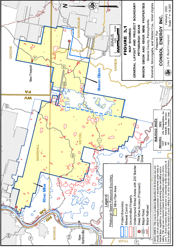
CONSOL’s Mason Dixon and River Mine Properties are greenfield sites located in Greene County, Pennsylvania and Marshall, Monongalia, and Wetzel counties, West Virginia. The properties comprise over 220 square miles within the NAPP coal-producing region of the eastern United States; as such, they comprise one of the largest undeveloped Pittsburgh Seam properties. The general location of the Mason Dixon and River Mine Properties is shown in Figure 1.1, following this page.
As illustrated in Figure 1.1, the Pittsburgh Seam has been and continues to be extensively mined in and around the Mason Dixon and River Mine Properties. CONSOL has a lengthy history of successfully mining the Pittsburgh Seam and other coal beds in the region.

The Mason Dixon and River Mine Properties, which are approximately 12 miles southwest of Waynesburg, Pennsylvania (near the town of Moundsville, West Virginia and the city of Woodsfield, Ohio), encompass approximately 141,445 acres. Of this acreage, CONSOL owns the coal rights to 127,103 acres either fully, fractionally, or by lease.
1.3 Geology
The Mason Dixon and River Mine Properties are situated in the Allegheny Plateau of the NAPP coal fields region. Near‑surface geology of this area primarily consists of Pennsylvanian and Lower Permian coal-bearing strata. Coal seams mined in this region are generally classified as high- to low-volatile bituminous, characterized by low‑to high‑sulfur content and high heating value.
The Pittsburgh Seam is the only coal seam of economic interest on the property. Structurally, the Pittsburgh Seam consists of three rather distinct and relatively consistent intervals: the main bench coal, an overlying draw slate, and a roof coal zone. With an average thickness of 6 ft, the main bench coal constitutes most of the mineable interval. The Pittsburgh Seam is relatively flat-lying, typically dipping less than one degree, and is located at depths ranging from approximately 300 ft to 1,400 ft below ground surface within the combined property areas.
The Pittsburgh Seam coal bed is characterized as a high-rank, high-volatile bituminous, medium-ash, and medium- to high-sulfur coal that is used for both thermal and metallurgical purposes.
1.4 Exploration
The Pittsburgh Seam has been extensively explored and mined in the region, with drilling records dating back to at least the 1920s. CONSOL provided data for 1,312 drill holes that have intercepted the Pittsburgh Seam in and around the Mason Dixon and River Mine Properties. Data from these drill holes were utilized to define the lateral extent, thickness, and qualities (both raw and clean) of the Pittsburgh Seam in the immediate project area.
BOYD’s audit indicates that in general: (1) CONSOL has performed extensive drilling and sampling work on the subject properties, (2) the work completed has been done by competent personnel, and (3) the amount of data available combined with wide-spread knowledge of the Pittsburgh Seam, is sufficient to confirm the thickness, lateral extents, and quality characteristics of the Pittsburgh Seam.
1.5 Coal Resources/Reserves
This technical report summary provides CONSOL’s estimates of coal resources for the Mason Dixon and River Mine Properties in accordance with the requirements set forth in S‑K 1300. These estimates are the result of a thorough geologic investigation of the properties, appropriate modeling of the deposit, development of conceptual mine plans, and consideration of the relevant processing, economic, marketing, legal, environmental, socio-economic, and regulatory factors.
CONSOL’s estimated potentially underground mineable coal resources for the Mason Dixon and River Mine Properties total 884.5 million clean recoverable tons as of December 31, 2021. The coal resources reported in Table 1.1 are based on conceptual plans utilizing mining and coal processing methods which have been commercially successful at similar operations in the region.
|
Table 1.1: Coal Resources Summary |
||||||||||||||||||||||||||
|
Average Product Quality (As Received Basis) |
||||||||||||||||||||||||||
|
Clean Recoverable |
% |
Heating |
||||||||||||||||||||||||
|
Area |
Classification |
Tons (millions) |
Total Moisture |
Ash |
Volatile Matter |
Sulfur |
Value (Btu/lb) |
|||||||||||||||||||
|
Mason Dixon |
Measured |
106.6 | 6.30 | 7.7 | 37.4 | 2.60 | 13,035 | |||||||||||||||||||
|
Indicated |
158.4 | 6.30 | 7.7 | 37.5 | 2.66 | 13,020 | ||||||||||||||||||||
|
Inferred |
8.9 | 6.30 | 7.6 | 38.2 | 2.86 | 12,971 | ||||||||||||||||||||
|
Total |
273.9 | 6.30 | 7.7 | 37.5 | 2.64 | 13,024 | ||||||||||||||||||||
|
River Mine |
Measured |
46.2 | 6.30 | 8.6 | 39.2 | 3.67 | 12,760 | |||||||||||||||||||
|
Indicated |
498.3 | 6.30 | 8.6 | 38.7 | 3.43 | 12,761 | ||||||||||||||||||||
|
Inferred |
66.1 | 6.30 | 9.3 | 39.5 | 3.95 | 12,615 | ||||||||||||||||||||
|
Total |
610.6 | 6.30 | 8.7 | 38.8 | 3.50 | 12,745 | ||||||||||||||||||||
|
Total - All Areas |
Measured |
152.8 | 6.30 | 8.0 | 38.0 | 2.93 | 12,952 | |||||||||||||||||||
|
Indicated |
656.7 | 6.30 | 8.4 | 38.4 | 3.24 | 12,823 | ||||||||||||||||||||
|
Inferred |
75.0 | 6.30 | 9.1 | 39.3 | 3.82 | 12,657 | ||||||||||||||||||||
|
Total |
884.5 | 6.30 | 8.4 | 38.4 | 3.24 | 12,831 | ||||||||||||||||||||
The reported coal resources include only coal which is reportedly owned or leased as of December 31, 2021. CONSOL owns 873.1 million clean recoverable tons, or 98.7% of the coal resources, with the remainder held under lease agreements.
Based on our review of CONSOL’s well-documented geologic modeling and estimation techniques, we are of the opinion that CONSOL’s resource estimation procedures are reasonable and appropriate. Furthermore, it is BOYD’s independent and professional opinion that the estimates of coal resources reported herein are suitable for public disclosure in compliance with Subpart 1300 of Regulation S-K. The stated coal resources may be materially affected if mining, geological, economic, or regulatory factors change from those currently anticipated for the Mason Dixon and River Mine Properties.
Insufficient technical studies have been conducted to establish the technical, economic, and legal viability of any coal reserves for the properties. As such, there are no coal reserves for the Mason Dixon and River Mine Properties to report as of December 31, 2021.
1.6 Conclusions
It is BOYD’s overall conclusion that CONSOL’s estimates of coal resources, as reported herein: (1) were prepared in conformance with accepted industry standards and practices, and (2) are reasonably and appropriately supported by technical evaluations. We do not believe there is other relevant data or information material to the Mason Dixon and River Mine Properties that would render this technical audit misleading. Our conclusions represent only informed professional judgment.
Given CONSOL’s lengthy history in the Pittsburgh Seam coal bed and with similar operations, residual uncertainty for this project is considered minor under the current and foreseeable operating environment. A general assessment of risk is presented in the relevant sections of this report.
The ability of CONSOL, or any mine operator, to recover all the reported coal resources is dependent on numerous factors that are beyond the control of, and cannot be anticipated by, BOYD. These factors include mining and geologic conditions, the capabilities of management and employees, the securing of required approvals and permits in a timely manner, future coal prices, etc. Unforeseen changes in regulations could also impact the estimates presented herein. Opinions presented in this report apply to the site conditions and features as they existed at the time of BOYD’s investigations and those reasonably foreseeable.
2.0 INTRODUCTION
2.1 Registrant and Purpose
CONSOL is a US-based mining company headquartered in Canonsburg, Pennsylvania whose common stock is listed on the New York stock exchange (NYSE:CEIX). CONSOL does not have definitive near-term plans to develop and produce thermal coal from the Mason Dixon and River Mine Properties. The company operates the Pennsylvania Mining Complex (PAMC) and is also in the process of developing the Itmann No. 5 Mine in Wyoming County, West Virginia that will produce metallurgical coal. In addition, CONSOL controls considerable greenfield (i.e., undeveloped) thermal and metallurgical coal resources located in the major coal-producing basins of the eastern United States. The company also owns and operates the CONSOL Marine Terminal, which is in the Port of Baltimore, Maryland. Additional information regarding CONSOL can be found at www.consolenergy.com.
This technical report summary was prepared for CONSOL in support of their disclosure of coal resources for the Mason Dixon and River Mine Properties. While the Properties are generally considered separate and distinct projects by CONSOL, for the purposes of S-K 1300 disclosure, the Properties are considered to share synergies (e.g., adjacent properties in the same coal seam) that support their inclusion under the same cover.
2.2 Terms of Reference
CONSOL retained BOYD to complete an independent assessment of CONSOL’s internally‑prepared coal resource estimates and supporting information for the Mason Dixon and River Mine Properties. Our objective was to review and evaluate the scientific and technical information on which CONSOL's calculation of its coal resource estimates are based.
The technical summary of our third-party assessment, presented in report form herein, was prepared in accordance with the disclosure requirements set forth in Subpart 1300 and Item 601(b)(96) of the SEC’s Regulation S-K. The purpose of this report is: (1) to summarize technical and scientific information for the subject mining properties, (2) to provide the conclusions of our technical audit, and (3) to provide a statement of coal resources for the Mason Dixon and River Mine Properties. This is the first technical report summary filed by CONSOL for the Mason Dixon and River Mine Properties.
BOYD’s findings are based on our detailed examination of the supporting geologic and other scientific, technical, and economic information provided by CONSOL, as well as our assessment of the methodology and practices applied by CONSOL in formulating the estimates of coal resources disclosed in this report. We did not independently estimate coal resources from first principles.
We used standard engineering and geoscience methods, or a combination of methods, that we considered to be appropriate and necessary to establish the conclusions set forth herein. As in all aspects of mining property evaluation, there are uncertainties inherent in the interpretation of engineering and geoscience data; therefore, our conclusions necessarily represent only informed professional judgment.
This report is intended for use by CONSOL subject to the terms and conditions of its professional services agreement with BOYD. We also consent to CONSOL filing this report as a technical report summary with the U.S. Securities and Exchange Commission (SEC) pursuant to Subpart 1300 and Item 601(b)(96) of Regulation S-K.
2.3 Expert Qualifications
BOYD is an independent consulting firm specializing in mining-related engineering and financial consulting services. Since 1943, BOYD has completed over 4,000 projects in the United States and more than 60 other countries. Our full-time staff comprises experts in: geology and geological modeling; civil, environmental, geotechnical, and mining engineering; mineral economics; and valuation and market analysis. Our extensive experience in coal resources/reserve estimation and our knowledge of the subject coal property, provides BOYD an informed basis on which to opine on the reasonableness of the estimates provided by CONSOL. An overview of BOYD can be found on our website at www.jtboyd.com.
The individuals primarily responsible for this audit and the preparation of this report are by virtue of their education, experience, and professional association considered qualified persons as defined in S-K 1300.
Neither BOYD nor its staff employed in the preparation of this report have any beneficial interest in CONSOL, and are not insiders, associates, or affiliates of CONSOL. The results of our audit were not dependent upon any prior agreements concerning the conclusions to be reached, nor were there any undisclosed understandings concerning any future business dealings between CONSOL and BOYD. This report was prepared in return for fees based upon agreed commercial rates, and the payment for our services was not contingent upon our opinions regarding the project or approval of our work by CONSOL and its representatives.
2.4 Principal Sources of Information
Information used in this assignment was obtained from: (1) CONSOL files, (2) discussions with CONSOL personnel, (3) records on file with regulatory agencies, (4) public sources, and (5) nonconfidential BOYD files.
The following information was provided by CONSOL:
|
● |
Year-end resource statements and reports for 2020 and 2021. |
|
● |
Exploration records (e.g., drilling logs, lab sheets). |
|
● |
Geologic databases of lithology and coal quality. |
|
● |
Computerized geologic models. |
|
● |
Mapping data, with: |
|
- |
Mineral tenure boundaries. |
|
- |
Permit boundaries. |
|
- |
Limits of previous mining. |
Information from sources external to BOYD and/or CONSOL are referenced accordingly.
The data and work papers used in the preparation of this report are on file in our offices.
2.5 Personal Inspections
A personal inspection of the Mason Dixon and River Mine Properties was not made by BOYD. The property is undeveloped, and the coal resources lie deep beneath the surface. BOYD has well-established knowledge of the subject and adjacent properties having performed over 100 engineering studies on the Pittsburgh Seam coal bed. As such, a field examination of the property was not considered necessary for the purposes of this audit and it is not believed that any information garnered from site visits would materially affect the findings of this report.
2.6 Effective Date
The coal resources presented in this technical audit are effective as of December 31, 2021. The report effective date is December 31, 2021.
2.7 Units of Measure
The US customary measurement system has been used throughout this report. Tons are short tons of 2,000 pounds-mass. Unless otherwise stated, all currency is expressed in constant 2021 US Dollars ($).
3.0 PROPERTY OVERVIEW
3.1 Property Location
CONSOL’s Mason Dixon and River Mine Properties are greenfield (i.e., undeveloped) mining properties located in Greene County, Pennsylvania and Marshall, Monongalia, and Wetzel counties, West Virginia. The properties comprise over 220 square miles within the NAPP coal-producing region of the eastern United States; as such, it is one of the largest undeveloped Pittsburgh Seam properties. An extensive natural gas storage field, known as the Victory Storage Field, lies beneath the resource area at depths of between 600 ft to 2,100 ft below the Pittsburgh Seam coal bed.
The Mason Dixon and River Mine Properties are located approximately 8 miles south of the town of Moundsville, West Virginia, approximately 12 miles southwest of the city of Waynesburg, Pennsylvania, and approximately 8 miles east of the city of Woodsfield, Ohio. The property extends westward to the Ohio River and is flanked by adversely controlled properties to the north and east. The southwest border of the Mason Dixon and River Mine Properties generally coincides with the known limits of the potentially mineable Pittsburgh Seam.
Geographically, the center of the Mason Dixon and River Mine Properties is located at approximately 39°40’02.77” N latitude and 80°34’20.61” W longitude. Figures 1.1 (page 1-2) and 3.1, following this page, illustrate the general location of the properties.
3.2 Property Control
According to information provided by CONSOL, the Mason Dixon and River Mine Properties comprise over 141,000 acres of mineral (coal) and/or surface rights. Ownership of the surface rights and the mineral rights is often severed for the properties. It is our understanding CONSOL and its predecessors have acquired the necessary rights to liberate the Pittsburgh Seam on the property through purchase or lease agreements with various third parties.
BOYD has not independently verified CONSOL’s ownership of the Mason Dixon and River Mine Properties and the underlying agreements. For reporting purposes, furnished ownership data, including maps, deeds, and royalty rates, have been accepted as being true and accurate.
3.2.1 Coal Ownership
CONSOL maintains the right to mine and remove almost all of the Pittsburgh Seam within the boundary of the Mason Dixon and River Mine Properties through whole or fraction mineral ownership and/or lease agreements, as summarized in Table 3.1.
|
Table 3.1: Summary of Pittsburgh Seam Coal Ownership |
||||||||||||||||
|
Tracts Overlaying |
||||||||||||||||
|
All Tracts |
Coal Resources |
|||||||||||||||
|
Acres |
% |
Acres |
% |
|||||||||||||
|
Owned: |
||||||||||||||||
|
Fully |
91,141 | 64.4 | 87,947 | 63.9 | ||||||||||||
|
Fractionally |
22,615 | 16.0 | 22,360 | 16.3 | ||||||||||||
|
Subtotal |
113,756 | 80.4 | 110,307 | 80.2 | ||||||||||||
|
Leased |
13,347 | 9.4 | 13,222 | 9.6 | ||||||||||||
|
Adverse/Uncontrolled |
14,342 | 10.1 | 13,996 | 10.2 | ||||||||||||
|
Total |
141,445 | 100.0 | 137,525 | 100.0 | ||||||||||||
As shown, CONSOL controls approximately 90% (on an active basis) of the mineral rights to the Pittsburgh Seam within the Mason Dixon and River Mine Properties. Several adversely controlled properties totaling approximately 14,000 acres are found within the property. It is reasonable to assume that these tracts can be purchased or leased as required to advance mining operations during the ordinary course of business. It is BOYD’s opinion that adverse coal control does not pose a material risk to the estimate of coal resources reported herein.
3.2.2 Surface Ownership
CONSOL reports that it directly owns approximately 5,151 surface acres within the property area. These surface rights were acquired for siting various mining, processing, and related facilities.
3.3 Regulation and Liabilities
Mining and related activities on the Mason Dixon and River Mine Properties will be regulated by both federal and state laws. The relevant federal laws include:
|
● |
Clean Air Act of 1970/1977 |
|
● |
Clean Air Act Amendments of 1990 |
|
● |
Clean Water Act of 1977 |
|
● |
Surface Mining Control and Reclamation Act of 1977 |
|
● |
Resource Conservation and Recovery Act of 1976 |
In Pennsylvania and West Virginia, responsibility for enforcing these acts, with the aid of numerous state laws and legislative rules, lies with the states’ Department of Environmental Protection.
As mandated by these laws and regulations, numerous permits are required for underground mining, coal preparation and related facilities, and other incidental activities. CONSOL holds and maintains four mining permits with the state of West Virginia covering a deep mine, preparation plant, refuse disposal area, and fresh water impoundment for the Mason Dixon property. Four associated National Pollutant Discharge Elimination System (NPDES) permits are also held and maintained for these sites.
Permits generally require that the permittee post a performance bond in an amount established by the regulator program to: (1) provide assurance that any disturbance or liability created during mining operation is properly mitigated; and (2) assure that all regulation requirements of the permit are fully satisfied.
If and when the properties are developed and operational, regular inspection of the mining operation and related facilities will be conducted by the Mine Safety and Health Administration (MSHA) for health and safety compliance. Any violation of health or safety standards will result in the issuance of a citation that specifies the standard violated and evaluates the gravity of the violation by several factors, including likelihood of injury. Any infraction that is reasonably likely to result in a serious injury or illness or is caused by the operator's unwarrantable failure to comply with regulatory requirements will carry additional fines and could result in temporary closure. Typically, the civil penalty for regular assessments is not considered material.
BOYD is not aware of any preexisting conditions and/or legal impediments which would prohibit CONSOL from securing the necessary permits or other regulatory approvals to develop the Mason Dixon and River Mine Properties. It should be noted that failure to secure the required government or other regulatory approvals or permits in a timely manner and/or CONSOL’s inability to obtain such required approvals or permits could materially impact development of the property.
4.0 PHYSIOGRAPHY, ACCESSIBILITY, AND INFRASTRUCTURE
4.1 Topography, Elevation, and Vegetation
The Mason Dixon and River Mine Properties lie within the Ohio Hills Section of the Appalachian Plateaus physiographic province of West Virginia. This region is characterized by very hilly topography, with narrow hilltops and dendritic valleys which display steeply sloping hillsides and moderate relief. Surface elevations above mean sea-level within the Mason Dixon and River Mine Properties range from approximately 700 ft (in the northwestern portion of properties) to 1,600 ft (at various hilltops throughout the Mason Dixon property). There are numerous overlying streams which cover the properties.
Land cover within the area consists predominantly of mixed forest and crop/pastureland dotted with low-density (rural) residential areas.
4.2 Accessibility
The Mason Dixon and River Mine Properties are in a well-populated[1] region of northern West Virginia with a demonstrated history related to coal mining as well as other industries and services. The region is supported by a well-developed network of primary and secondary roads serviced by state and local governments. Roadways that traverse the property’s surface include State Routes 7, 18, 69, 89, and 250. This road network would offer direct access to the property site and are generally open year-round.
4.3 Climate
Climate in and around the property is typical of northern West Virginia, with four distinct seasons: cold winters; hot and humid summers; and mild falls and springs. The average daily high temperatures are above freezing 12 months of year while the low temperatures drop below freezing 3 months of the year. Table 4.1 provides monthly
1 According to the 2020 US Census, 1 million people reportedly live within a 50-mile radius of the property area.
average climate data collected by the National Weather Service from 1991 through October 2021 at Morgantown Municipal Airport, West Virginia.
|
Table 4.1: Monthly Average Climate Data - Morgantown Municipal Airport, WV |
||||||||||||||||||||||||||||||||||||||||||||||||
|
Jan |
Feb |
Mar |
Apr |
May |
Jun |
Jul |
Aug |
Sep |
Oct |
Nov |
Dec |
|||||||||||||||||||||||||||||||||||||
|
Average Temperature (°F) |
||||||||||||||||||||||||||||||||||||||||||||||||
|
High |
40.1 | 43.7 | 52.6 | 65.2 | 73.6 | 80.9 | 84.4 | 83.1 | 77.1 | 65.9 | 54.1 | 44.3 | ||||||||||||||||||||||||||||||||||||
|
Low |
24.0 | 25.8 | 32.6 | 42.4 | 51.5 | 59.7 | 63.8 | 62.5 | 55.9 | 44.7 | 35.8 | 28.6 | ||||||||||||||||||||||||||||||||||||
|
Average Precipitation |
||||||||||||||||||||||||||||||||||||||||||||||||
|
Inches |
3.1 | 2.8 | 3.7 | 3.8 | 4.2 | 4.2 | 5.0 | 3.8 | 3.4 | 3.2 | 3.0 | 3.3 | ||||||||||||||||||||||||||||||||||||
|
Days |
8.0 | 7.0 | 6.0 | 7.0 | 7.0 | 7.0 | 8.0 | 7.0 | 9.0 | 9.0 | 9.0 | 9.0 | ||||||||||||||||||||||||||||||||||||
|
Average Snowfall |
||||||||||||||||||||||||||||||||||||||||||||||||
|
Inches |
9.1 | 4.0 | 13.0 | 0.1 | 0.0 | 0.0 | 0.0 | 0.0 | 0.0 | 0.1 | 0.3 | 5.0 | ||||||||||||||||||||||||||||||||||||
|
Days |
5.0 | 4.0 | 4.0 | 0.0 | 0.0 | 0.0 | 0.0 | 0.0 | 0.0 | 0.0 | 1.0 | 4.0 | ||||||||||||||||||||||||||||||||||||
The surrounding area, which contains terrain with relatively high relief, has been prone to occasional flash flooding during heavy rain events. These extreme weather conditions are relatively rare in occurrence; however, there is the possibility that mining operations could be impacted during times of unusually heavy precipitation.
4.4 Infrastructure
Once developed, coal produced from the property would likely be transported on nearby Class 1 rail lines operated by rail service provider CSXT or directed onto the Ohio River for barge transport. Rail spurs, rail sidings and coal load out facilities that would service the Mason Dixon and River Mine Properties currently do not exist.
Several regional airports are located near the properties, with the Pittsburgh International Airport located approximately 70 miles north.
Sources of electrical power, water, supplies, and materials are readily available. Electrical power would be provided to the mines and facilities by regional utility companies while water would be supplied by public water services, surface impoundments, or water wells.
5.0 HISTORY
CONSOL’s involvement with the Mason Dixon and River Mine Properties and other Pittsburgh Seam holdings dates to the 1920s with the acquisition of certain coal leases by its forebearer. CONSOL has an extensive operating history and has been mining the Pittsburgh Seam for many decades.
The Pittsburgh Seam coal bed covers approximately 6,000 square miles in northern West Virginia, southwestern Pennsylvania, and eastern Ohio. The seam has been extensively mined over the past 100 years in areas having the best coal quality, easiest access, and preferential mining conditions (particularly in the eastern portion of the coalfield and along the Ohio River). Most of the Pittsburgh Seam’s active mining operations are situated between the Monongahela River (to the east) and the Ohio River
(to the west). Development of the extreme southwestern portions of the Pittsburgh Seam, where the Mason Dixon and River Mine Properties are located, has not been undertaken to date.
Existing Pittsburgh Seam operations consist predominately of mature underground mines employing similar extraction and beneficiation methods—namely, highly efficient longwall (LW) mines and coal preparation plants. Four companies: CONSOL, American Consolidated Natural Resources, Inc. (ACNR), Iron Senergy Holding, LLC (Iron Senergy), and Alliance Resource Partners LP (ARP)—account for all the production from the Pittsburgh Seam. In 2020, 11 LW mines produced approximately 58 million tons of Pittsburgh Seam coal, the majority of which was marketed into the thermal generation sector. Table 5.1 details the current Pittsburgh Seam operations.
|
Table 5.1: Historical Pittsburgh Seam Production |
||||||||||||||||||||||||||
|
Production Tons (000) |
||||||||||||||||||||||||||
|
Mine |
Operator |
State |
County |
2016 |
2017 |
2018 |
2019 |
2020 |
||||||||||||||||||
|
Bailey |
CONSOL |
PA |
Greene |
12,056 | 12,124 | 12,735 | 12,218 | 8,669 | ||||||||||||||||||
|
Century |
ACNR |
OH |
Monroe |
4,984 | 5,677 | 4,786 | 4,735 | 1,689 | ||||||||||||||||||
|
Cumberland |
Iron Senergy |
PA |
Greene |
6,960 | 6,770 | 6,423 | 6,595 | 5,621 | ||||||||||||||||||
|
Enlow Fork |
CONSOL |
PA |
Washington |
9,638 | 9,180 | 9,876 | 10,043 | 5,691 | ||||||||||||||||||
|
Federal No 2 |
Phoenix |
WV |
Monongalia |
1,507 | 1,104 | - | - | - | ||||||||||||||||||
|
Harrison County |
ACNR |
WV |
Marion / Wetzel |
6,587 | 7,131 | 7,215 | 6,809 | 4,880 | ||||||||||||||||||
|
Harvey |
CONSOL |
PA |
Greene |
2,971 | 4,805 | 4,981 | 5,024 | 4,410 | ||||||||||||||||||
|
Marion County |
ACNR |
WV |
Marion |
4,371 | 6,115 | 6,133 | 5,963 | 3,875 | ||||||||||||||||||
|
Marshall County |
ACNR |
WV |
Marshall |
10,524 | 11,654 | 11,434 | 11,719 | 8,855 | ||||||||||||||||||
|
Monongalia County |
ACNR |
WV |
Monongalia |
3,895 | 3,890 | 4,404 | 4,469 | 2,295 | ||||||||||||||||||
|
Ohio County |
ACNR |
WV |
Marshall |
6,266 | 6,047 | 6,509 | 6,601 | 4,999 | ||||||||||||||||||
|
Tunnel Ridge |
ARP |
WV |
Ohio |
6,593 | 6,988 | 6,807 | 7,330 | 6,757 | ||||||||||||||||||
| 76,352 | 81,484 | 81,303 | 81,506 | 57,741 | ||||||||||||||||||||||
|
Source: MSHA Form 7000-1 |
The number of Pittsburgh Seam mines in operation has remained relatively constant in recent history. In the last five years, only one Pittsburgh Seam mine—the Federal No. 2 mine operated by Phoenix Federal No.2 Mining, LLC—has been closed (in 2017 due to reserve depletion). Aside from ACNR’s Century and Monongalia County mines, which are closed and/or expected to deplete their remaining coal reserves soon, the remaining mines have significant coal reserves and are expected to continue operating for the foreseeable future.
Mines producing lower sulfur Pittsburgh Seam coal are located in eastern and southern Washington County and northern Greene County, Pennsylvania. Sulfur content of the Pittsburgh Seam generally increases to the south and west, with mines in southern Greene County and in Monongalia and Marion counties, West Virginia producing a higher sulfur content product than those in northern Greene and southern Washington counties. Mines producing the highest sulfur coal are in the West Virginia Panhandle counties of Brooke and Marshall and in eastern Ohio. Heat content (expressed in Btu/lb) of the Pittsburgh Seam coal generally declines to the west.
Due to the high ash content of the run-of-mine (ROM) coal produced by the existing underground mines, all Pittsburgh Seam production is washed before sale. In addition to their primary utility customers, a portion of the output from these mines is sold into the industrial sector and the domestic and international metallurgical market.
6.0 GEOLOGY
6.1 Regional Geology
The Mason Dixon and River Mine Properties are located within the Appalachian Basin, an oblong synclinal, sedimentary basin which extends from central Alabama to central New York State. The Appalachian Basin spans an area of about 185,000 square miles, with a length of around 1,075 miles, consisting of Paleozoic sedimentary rocks, dating from the Early Cambrian through the Early Permian periods.
The Appalachian Basin has informally been subdivided into three coal regions—the northern Appalachian (NAPP), central Appalachian (CAPP), and southern Appalachian (SAPP) Basin coal regions—based on characteristics of the sediments and the coals that are found there. The three coal regions contain both formal and informal coal fields. Physiographically, the Appalachian basin is divided into four distinct provinces, which from east to west are: the Piedmont, the Blue Ridge, the Valley and Ridge, and the Appalachian Plateaus. The Mason Dixon and River Mine Properties are located within the NAPP basin coal region of the Appalachian Plateaus province. This region is known to contain much of the coal, oil, and shale gas resources of the eastern United States.
The Allegheny Plateau, in which the properties are located, is a major part of the Appalachian Plateaus province, underlain by essentially flat-lying strata, predominately of Mississippian and Pennsylvanian age. Throughout the region, the strata of the Allegheny Plateau have been broadly uplifted and, in some areas, broadly folded as well, but in general these bedrock units are only minimally deformed.
A large portion of the Allegheny Plateau consists of a coalfield comprising Pennsylvanian and Lower Permian coal-bearing strata and include, in depositional order, bedrock of the Pottsville, Allegheny, Conemaugh, Monongahela, and Dunkard groups. These coal‑bearing formations contain approximately two-fifths of the nation’s bituminous coal deposits. In some portions, the coalfield contains over 60 coal seams of varying economic significance. Seams are typically between 1 ft and 6 ft in thickness, with relatively little structural deformation. Coal in the region is classified as high-to low‑volatile bituminous with rank increasing to the east. Coals are typically characterized as low- to high-sulfur and high heating value.
6.2 Local Stratigraphy
Pennsylvanian and Permian sedimentary strata comprise the uppermost stratigraphic units in and around the Mason Dixon and River Mine Properties. These units primarily include bedrock of, in ascending stratigraphic order, the Conemaugh and Monongahela Groups of the Pennsylvanian Series, and the Permian Dunkard Group.
The strata of the Pennsylvanian and Permian systems locally are predominantly clastic and contain subordinate amounts of coal and limestone. The Pittsburgh coal seam is the basal member of the Monongahela Group. The stratigraphic relationship between these groups is presented in Figure 6.1 as follows.
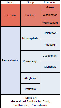
6.2.1 Conemaugh Group
The Conemaugh Group is characterized by sequences of red and green mudstone, claystone, and siltstone. Extending from the top of the Upper Freeport coal to the base of the Pittsburgh coal, it ranges in thickness from about 400 ft to 850 ft. The Conemaugh Group contains several thin marine limestone beds but only a few thin coal beds. The Conemaugh Group is divided into the Glenshaw and Casselman formations at the top of the regionally persistent Ames limestone. The bituminous coal beds present in the unit are impure and considered to be of limited-to-no economic value.
6.2.2 Monongahela Group
The Monongahela Group extends from the base of the Pittsburgh Coal to the base of the Waynesburg Coal. The unit is divided into the Pittsburgh and Uniontown formations at the base of the Uniontown Coal. The Monongahela Group is a sedimentary sequence of non-marine rocks (sandstone, siltstone, red and gray shale, dolomitic limestone, and coal) ranging in thickness from approximately 250 ft to 400 ft. Regionally, the Monongahela Group contains several commercial coal beds, including the Pittsburgh, Redstone, Sewickley, and Uniontown; however, within the vicinity of the properties, only the Pittsburgh coal seam is of economic interest. The Pittsburgh coal seam is unusually uniform in continuity and thickness (4 ft to 10 ft) for a coal seam in western Pennsylvania and covers thousands of square miles.
6.2.3 Dunkard Group
The Dunkard Group includes all strata above the base of the Waynesburg coal bed. It is made up of Waynesburg, Washington, and Greene formations. The Dunkard Group reaches a maximum thickness of about 1,100 ft in Greene County and the upper surface is the modern-day erosional surface. Strata of the group are very similar to those of the underlying Monongahela Group, except that the Dunkard Group contains only thin discontinuous coal beds of little or no commercial value.
6.3 Coal Seam Geology
The Pittsburgh Seam is very uniform in depositional nature and continuity throughout much of the surrounding region, with a lengthy history of economically viable mining operations being very well documented.
6.3.1 Lithology
The Pittsburgh Seam coal bed is composed of three distinct and relatively consistent intervals, in order of deposition being the thick “main bench” coal, an overlying “draw slate”, and one or more “roof coal” zones. Mining methods employed by Pittsburgh Seam mines generally necessitate extraction of the first (lowermost) roof coal zone, along with the draw slate and main bench coal. Figure 6.2 illustrates the various intervals of the Pittsburgh Seam coal bed.
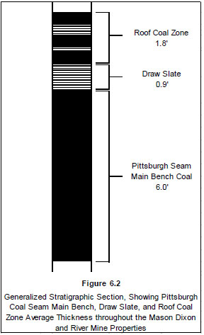
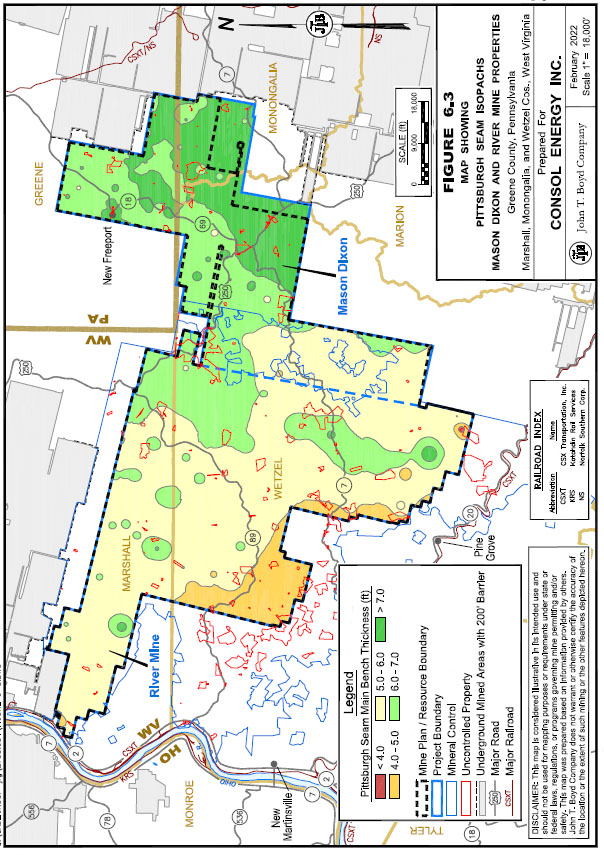
The main bench coal thickness across the Mason Dixon and River Mine Properties is generally between the 5.5 ft to 6.5 ft range. The main bench coal is generally thinner in the southwestern portion of the River Mine property, where drilling indicates thicknesses near 4.0 ft. The main bench then trends thicker towards the northeast, where occurrences of over 8.0 ft of main bench coal were recorded. Figure 6.3, following this page, provides a map of the Pittsburgh Seam main bench thickness throughout the Mason Dixon and River Mine Properties.
The draw slate is a prominent, laterally persistent shale parting that immediately overlies the main bench coal.
The roof coals tend to be of lesser quality when compared to the main bench coal, as well as being highly inconsistent in depositional nature. In some areas the roof coal may be completely absent; present as a solid interval of relatively thick coal; or split into several plies separated by shale, clay, and/or impure coal partings.
The immediate roof overlying the Pittsburgh Seam coal bed typically consists of one of two different assemblages of strata:
|
1. |
A “normal roof”, composed of interbedded shales and sandy shales, with one to several rider or roof coals. |
|
2. |
A “sandstone roof”, composed of paleochannel sandstone fill, known as the Pittsburgh Sandstone, which scoured and replaced part or all of the normal roof strata. |
The Pittsburgh Sandstone represents a major fluvial system that flowed north-northwest from West Virginia, through Greene and Washington counties, depositing sandstone in an elongated body up to 80-ft thick and several miles wide. The Pittsburgh Sandstone is a result of several instances of paleochannelization eroding the typical roof strata, and in some localized areas eroding some of the main bench of the Pittsburgh Seam. Areas of the deposit with sandstone channels near the Pittsburgh Seam commonly exhibit discontinuities and rolls in the coal bed. Poor roof conditions are also common along margins of the channels, where the roof type transitions between the sandstone roof and normal shale roof. In their nearby Pittsburgh Seam mines, CONSOL has implemented various programs to identify and mitigate, where possible, problems associated with poor roof conditions, and have a history of successfully doing so.
The immediate floor beneath the Pittsburgh Seam coal bed consists of an interval of typically 1 ft or less of underclay. The underclay provides a generally competent floor, however poor floor conditions can develop when the underclay is exposed to water.
6.3.2 Structure
The Pittsburgh Seam coal bed is located at depths ranging from approximately 300 ft to over 1,500 ft below ground surface within the properties. Seam structure shows a general seam dip of less than 1 degree to a low area in the center of the properties, with slightly steeper areas dipping to just over 1 degree in isolated areas in the western flanks of the River Mine property. There are no major structural faulting or tectonic features known to occur in the deposit. Small-displacement faults and compaction‑related faults may be present but are not expected to materially affect mining operations.
The structural setting for the deposit is generally considered to be simple in terms of geological complexity. Having been widely studied and extensively mined, the Pittsburgh Seam is well-known and widely accepted to be a very uniform deposit.
6.3.3 Coal Quality
Overall, the Pittsburgh Seam coal bed is a high-rank, high-volatile bituminous, medium‑ash, and medium- to high-sulfur coal that is used for both thermal and metallurgical purposes. The roof coal zones exhibit overall higher sulfur and ash contents, combined with lower calorific value; however, this is offset by the consistently superior quality of the main bench coal.
7.0 EXPLORATION DATA
7.1 Background
Records from exploration drilling comprise the primary data used in the evaluation of coal resources on the Mason Dixon and River Mine Properties. A database and geologic model with compiled results from 1,312 drill holes completed in and around the subject properties were reviewed. Additional data reviewed included: (1) select maps prepared by CONSOL illustrating thickness, ash, heat content, sulfur, volatile matter, and extent of the Pittsburgh Seam deposit, (2) electronic copies of original drilling and sampling logs, (3) coal quality testing results, (4) geologic modeling files and (5) third-party exploration reports.
Due to company-wide restructurings, closures of various mining operations, and reorganization of departments made by CONSOL over its many years in existence, specific drilling campaign reports, which would provide detailed information on the drilling and sampling methodologies utilized from year to year, were placed into archival storage and were not provided for our review. While this limits the detail associated with the exploration work completed for the Mason Dixon and River Mine Properties, BOYD recognizes CONSOL’s demonstrated ability to successfully complete comprehensive exploration and sampling programs and consistently and economically mine coal from the Pittsburgh Seam over the past century.
7.2 Procedures
7.2.1 Drilling
CONSOL geologists provided the following summary of equipment and procedures generally utilized in exploration work completed on the subject properties:
|
● |
Drilling equipment commonly utilized during exploration (depending on the goal of a specific drilling and sampling program) consists generally of one or both of: |
|
- |
Continuous NQ-sized (1.988 in. diameter) diamond core rigs. |
|
- |
Air rotary with either 4 in. or 6 in. diameter barrels. |
|
● |
Core logging activities are completed in the field. Cored intervals are photographed, with special attention paid to the coal interval. Cored coal is initially photographed in its entirety, and then again on 1-ft intervals from top to bottom to provide a detailed record of the coal core prior to sampling. |
|
● |
Coal roof rock (approximately 30 ft) and floor rock (up to 5 ft) are photographed and then boxed for archival purposes. Drilling campaigns from 2018 on have archival cores stored at CONSOL Headquarters, in Canonsburg, Pennsylvania. Historically, CONSOL maintained regionally located core repositories, however these locations have been closed, and all core prior to 2018 have been disposed of. |
|
● |
Geophysical logging on drill holes became standard starting in the mid-to-late 1970s. Prior to this time, geophysical logs were located for some drill holes, however they were much less frequently noted in the provided drill hole data files. CONSOL has noted that geophysical logging is currently completed on all holes drilled. |
Due to the large extent of historic exploration work in and around the Mason Dixon and River Mine Properties, any recent drilling is generally for infilling areas with lower geologic assurance. In such instances, nearby drill hole records are referenced prior to commencing any new drill holes, to show the anticipated depth to the coal horizons.
Geophysical logs obtained from newly drilled holes are correlated by CONSOL geologists by aligning known “marker beds”, and then checking coal seam depths, elevations, and thicknesses to ensure seam continuity. These data are formatted and then imported into CONSOL’s geologic modeling and mine production forecasting programs.
BOYD’s review of the reported methodologies and procedures indicate the data obtained and utilized by CONSOL were carefully and professionally collected, prepared, and documented, conforming with general industry standards, and are appropriate for use of evaluating and estimating coal resources.
7.2.2 Coal Quality Sampling
Coal quality testing was performed on many samples from the Pittsburgh Seam coal bed collected in and around the Mason Dixon and River Mine Properties. The relatively dense core drilling coverage provides an understanding of the coal quality of the Pittsburgh Seam underlying the properties. Data from drilling and testing completed outside the extents of the combined properties were not reviewed due to their lack of influence within the proposed mining areas.
Pittsburgh Seam coal intercepts were geologically logged, photographed, and sampled in the field by CONSOL geologists. Explicit instructions are given to drilling teams to keep any cored coal intervals inside of core barrels until a CONSOL geologist is on-site to observe and record characteristics of the coal interval.
Sampling methodologies consist of first pushing the cored intervals of coal out of the core barrel, directly into a clean single-row wooden core box. Prior to removing coal core from the drilling barrel, the core box is lined with durable plastic sheeting, which helps retain moisture content and minimize coal core oxidation. Once the coal core is fully extruded from the core barrel, it is then inspected, photographed, and logged by the on‑site geologist, and cardboard inserts are installed in the wooden core box to maintain coal core integrity.
Upon completing detailed recording (geologic logging and photographing) of the coal interval, coal cores are split into the desired intervals to be analyzed (i.e., entire seam, main bench, roof coal, etc.) and bagged. An order sheet is placed inside the sample bag, which specifies drill hole information, split information, and testing to be completed on the bagged sample. Sample bags are then zip tied closed, labeled, and then double bagged to eliminate incidental core loss due to potential damage during transportation to the testing lab. It is important to note that CONSOL has various internal departments that may request exploration and sampling work be conducted, and the requesting department is given priority as to how the coal intercept is split, and as to the types of coal analyses that are run.
CONSOL maintains all control of coal core samples, up to the point that samples are handed over to the lab performing testing. Once logging and sampling is complete, the sampled coal core intervals are transported to CONSOL headquarters by exploration personnel, at which time they are handed over to CONSOL’s quality control department. The quality control department arranges pick up by the selected lab that will perform the required analyses. Currently, CONSOL contracts all testing to an independent laboratory, Geochemical Testing in Somerset, Pennsylvania. Typical analyses performed include moisture content (total and air dried at 60-mesh), full proximate, and specific gravity. The lab manager signs off on the return analysis sheet, indicating that testing results are accurate and that the sample provided was sufficient for testing purposes.
Past programs utilized a myriad of various accredited coal testing laboratories, again depending on what testing needed to be completed on the coal core at a given time. All analytical work was conducted to International Organization of Standardization (ISO) or ASTM International (ASTM) standards, and various available laboratory sample sheets were provided for review with drilling log data.
Available testing sheets were reviewed by BOYD during our drill hole data audit, and our review of the field and sampling procedures noted above showed that the general description and sampling work were conducted to appropriate standards. Based on the stated standards and laboratory used, BOYD considers the sample preparation and analytical procedures were adequate for the coal quality results for inclusion in geological modelling and coal resource estimation.
7.2.3 Coal Washability Testing
Coal washability tests at various specific gravities (generally ranging from 1.40 FL through 1.60 FL) were conducted on the Mason Dixon and River Mine Properties. Proximate analysis test results were completed on nearly all the drill core samples. These data were used in estimating product coal quantities and qualities.
Lab testing of the cored coal intervals was conducted through: (1) a full seam analysis of the coal and all partings together, and (2) individual analyses performed on each individual coal and parting split encountered during drilling. Twenty drill holes were submitted for petrographic analyses to determine the seam’s metallurgical coal properties.
Although CONSOL generally does not perform any randomized sample verification for quality control testing of individual coal analyses, the generally low variation of quality results over the properties suggest the analyses are in-line with anticipated product coal quality.
7.2.4 Other Exploration Methods
No other methods of exploration (such as airborne or ground geophysical surveys) were reportedly used in the project area.
7.3 Results
7.3.1 Summary of Exploration
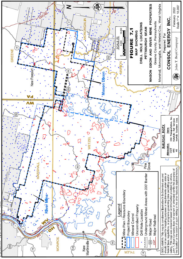
A total of 1,312 drill hole locations distributed across the Mason Dixon and River Mine Properties area were included in CONSOL’s geologic model. The distribution of drill holes is shown on Figure 7.1, following this page.
7.3.2 Adequacy of Exploration
General descriptive statistics for the three intervals of the Pittsburgh Seam are provided in Table 7.1. As shown, the thickness of the main bench is very consistent. Our analysis
of drilling data indicates a very minor decrease in the thickness of the main bench when traversing the deposit from south to north.
|
Table 7.1: Descriptive Statistics, Pittsburgh Seam Thickness |
||||||||||||
|
Interval Thickness (feet) |
||||||||||||
|
Main Bench |
Draw Slate |
Roof Coal |
||||||||||
|
Mean |
6.06 | 0.86 | 1.83 | |||||||||
|
Minimum |
3.64 | 0.06 | 0.16 | |||||||||
|
Maximum |
8.27 | 4.16 | 9.24 | |||||||||
|
Standard Deviation |
0.09 | 0.09 | 0.21 | |||||||||
|
Coefficient of Variance |
0.01 | 0.11 | 0.11 | |||||||||
Coal quality within the mine plan area, based on analyses of the modeled drill hole data, are summarized in Table 7.2.
|
Table 7.2: Descriptive Statistics, Pittsburgh Seam Quality Analyses |
|||||||||||||||||||||
|
Standard |
Coefficient |
||||||||||||||||||||
|
Units |
Mean |
Minimum |
Maximum |
Deviation |
of Variance |
||||||||||||||||
|
Apparent Specific Gravity |
g/cc |
1.56 | 1.40 | 2.27 | 0.02 | 0.01 | |||||||||||||||
|
Raw Coal Quality |
|||||||||||||||||||||
|
Ash |
% |
30.4 | 15.5 | 68.4 | 1.13 | 0.04 | |||||||||||||||
|
Clean Coal Quality (1.60 Float) |
|||||||||||||||||||||
|
Yield |
% |
65.7 | 4.6 | 86.9 | 1.79 | 0.03 | |||||||||||||||
|
Ash |
% |
8.5 | 6.6 | 76.1 | 1.87 | 0.22 | |||||||||||||||
|
Sulfur |
% |
3.23 | 1.57 | 5.76 | 0.08 | 0.03 | |||||||||||||||
|
Heating Value |
Btu/lb |
12,850 | 9,897 | 13,299 | 82.58 | 0.01 | |||||||||||||||
|
Volatile Matter |
% |
38.3 | 34.4 | 42.1 | 0.15 | - | |||||||||||||||
|
Note: Raw and clean coal qualities are provided on a "recoverable" seam thickness, dry basis. |
|||||||||||||||||||||
BOYD’s audit indicates that in general: (1) CONSOL has performed sufficient drilling and sampling work on the subject properties to support the estimation of coal resources, (2) the work completed has been done by competent personnel, and (3) the amount of data available combined with wide-spread knowledge of the Pittsburgh Seam is sufficient to confirm the thickness, lateral extents, seam uniformity and continuity and quality characteristics throughout the Mason Dixon and River Mine Properties area.
7.4 Data Verification
For purposes of this report, BOYD did not verify historic drill hole data by conducting independent drilling in areas already explored. It is customary in preparing coal resource and reserve estimates to accept basic drilling and coal quality data as provided by the client subject to the reported results being judged representative and reasonable.
BOYD’s efforts to judge the appropriateness and reasonability of the source exploration data included reviewing a representative sample of drilling logs and coal quality test results for holes on the Mason Dixon and River Mine Properties. These records were compared with their corresponding database records for transcription errors; of which none were found. Lithologic and coal quality data points were compared via visual and statistical inspection with geologic mapping and cross‑sections.
8.0 SAMPLE PREPARATION, ANALYSIS, AND SECURITY
Information regarding coal quality sampling and analysis is provided in Chapter 7.
9.0 DATA VERIFICATION
Refer to Section 7.4 of this report for details regarding the qualified persons data verification efforts.
10.0 MINERAL PROCESSING AND METALLURGICAL TESTING
Information regarding coal washability testing is provided in Chapter 7.
11.0 COAL RESOURCE ESTIMATE
11.1 Applicable Standards and Definitions
Unless noted, the estimates of coal resources disclosed herein are done so in accordance with the standards and definitions provided by S-K 1300. It should be noted that BOYD considers the terms “mineral” and “coal” to be generally interchangeable within the relevant sections of S-K 1300.
Estimates of coal resources and coal reserves are always subject to a degree of uncertainty. The level of confidence that can be applied to a particular estimate is a function of, among other things: the amount, quality, and completeness of exploration data; the geological complexity of the deposit; and economic, legal, social, and environmental factors associated with mining the resource/reserve. By assignment, BOYD used the definitions provided in S-K 1300 to describe the varying degree of certainty associated with the estimates reported herein.
The definition of mineral (coal) resource provided by S-K 1300 is:
Mineral resource is a concentration or occurrence of material of economic interest in or on the Earth's crust in such form, grade or quality, and quantity that there are reasonable prospects for economic extraction. A mineral resource is a reasonable estimate of mineralization, taking into account relevant factors such as cut-off grade, likely mining dimensions, location or continuity, that, with the assumed and justifiable technical and economic conditions, is likely to, in whole or in part, become economically extractable. It is not merely an inventory of all mineralization drilled or sampled.
Estimates of coal resources are subdivided to reflect different levels of geological confidence into measured (highest geologic assurance), indicated, and inferred (lowest geologic assurance). See Glossary of Abbreviations and Definitions.
The definition of mineral (coal) reserve provided by S-K 1300 is:
Mineral reserve is an estimate of tonnage and grade or quality of indicated and measured mineral resources that, in the opinion of the qualified person, can be the basis of an economically viable project. More specifically, it is the economically mineable part of a measured or indicated mineral resource, which includes diluting materials and allowances for losses that may occur when the material is mined or extracted.
Estimates of coal reserves are subdivided to reflect geologic confidence, and potential uncertainties in the modifying factors, into proven (highest assurance) and probable. See Glossary of Abbreviations and Definitions.
Figure 11.1 shows the relationship between coal resources and coal reserves.
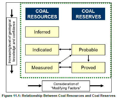
Figure 11.1: Relationship Between Coal Resources and Coal Reserves
By request and in accordance with CONSOL’s internal reporting conventions, estimates of coal resources are provided on a “clean, recoverable tons” basis, which includes mining losses and dilution based on an assumed mining method and product yield derived from washability test results. Coal resources that are not coal reserves do not have demonstrated economic viability.
11.2 Coal Resources
11.2.1 Methodology
Based on provided information, CONSOL’s coal resources estimation and modeling techniques consists of:
|
1. |
Interpreted and correlated coal seam intercepts are compiled and validated. Seam thickness is aggregated and coal qualities are composited, based on assumed mining methods, for each data point. |
|
2. |
Boundaries of the respective resource classification regions are developed using the data points. |
|
3. |
ROM coal thickness and coal qualities for each data point are derived from the application of dilution parameters. |
|
4. |
Clean product qualities for each data point are derived from coal washability analysis and plant efficiency factors. |
|
5. |
The approved life of mine design is subdivided into small mining blocks and sequenced using CONSOL’s proprietary mine planning software. |
|
6. |
In-place, ROM, and clean product estimates of coal volume and qualities for each mining block are estimated within the mine planning software by inverse distance interpolation of the data points developed in Steps 1 and 2. |
|
7. |
The mining blocks (and associated volumetric data) are further subdivided by resource classification and property tract polygons. |
|
8. |
Relevant regional and periodic summaries are prepared within CONSOL’s software to support planning and coal resource/reserve reporting. |
11.2.2 Criteria
Development of the coal resource estimate for the Mason Dixon and River Mine Properties assumes mining using standard underground development and LW methods and equipment, which have been utilized successfully by CONSOL at their mining operations for over 35 years.
The reported coal resources are delineated by a conceptual underground mine design employing conventional LW and continuous miner (CM) development methods. The mine plans address anticipated geologic, geotechnical, and hydrogeologic conditions. A minimum mineable seam thickness of 4 ft was used to limit the coal resources. This thickness includes the Pittsburgh Seam main bench plus portions of the draw slate and roof coal as necessitated by assumed mining methods. No other cut-offs were applied. Mining and processing parameters were assumed based on CONSOL’s extensive mining history in other Pittsburgh Seam operations.
Table 11.1 summarizes the mining-related parameters used by CONSOL in the estimation of coal resources.
|
Table 11.1: Mining and Processing Parameters |
||||||||||
|
Mining Method |
||||||||||
|
Parameter |
Units |
Development |
Longwall |
|||||||
|
Mining Recovery |
% |
21 –80 | 99 | |||||||
|
Dilution: |
||||||||||
|
Amount |
feet |
0.30 | 0.30 | |||||||
|
ASG |
g/cc |
2.40 | 2.40 | |||||||
|
Ash |
%, db |
83.0 | 83.0 | |||||||
|
Sulfur |
%, db |
3.00 | 3.00 | |||||||
|
Heating Value |
btu/lb, db |
1,500 | 1,500 | |||||||
|
ROM Adjustments: |
||||||||||
|
Ash |
%, db |
1.0 | 1.0 | |||||||
|
Sulfur |
%, db |
0.10 | 0.10 | |||||||
|
Product Adjustments: |
||||||||||
|
Yield Adjustment |
%, ar |
-2.00 | -2.00 | |||||||
|
Moisture |
%, ar |
6.30 | 6.30 | |||||||
|
ASG - apparent specific gravity |
||||||||||
Mining recovery varies by mining method and design. LW mining recovery is generally very good. The estimated average mining recovery for the Mason Dixon and River Mine Properties are considered reasonable.
Clean coal estimates are based on washability (Float 1.60) data, which are adjusted (reduced) to reflect practical yields achieved by a typical coal preparation plant. The average clean coal yield for the resources is 70%. Figure 11.2 depicts the estimated product yield for the recoverable Pittsburgh Seam across the properties. Product moisture was assumed to be 6.3% (as-received basis).
BOYD has reviewed CONSOL’s mining and processing assumptions as they pertain to the estimation and reporting of coal resources for the Mason Dixon and River Mine Properties and is of the opinion that they are reasonable.
11.2.3 Classification
Geologic assuredness is established by the availability of both structural (thickness and elevation) and quality information for the Pittsburgh Seam. Classification is generally based on the concentration or spacing of exploration data, which can be used to
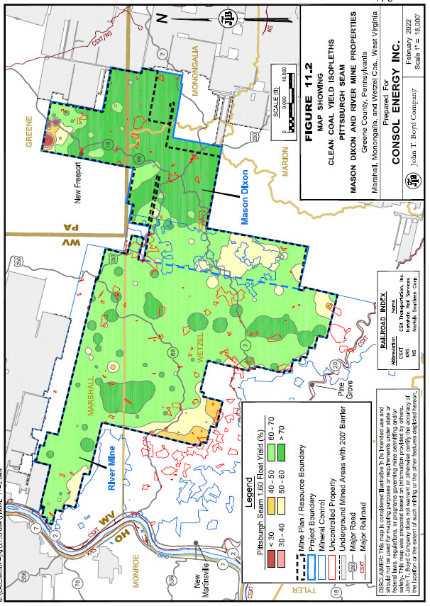
demonstrate the geologic continuity of the deposit. Table 11.2 provides the general criteria employed in the classification of the coal resources.
|
Table 11.2: Coal Resource Classification Criteria |
||||||||||||||||||||||||
| Classification | Data Point Spacing | |||||||||||||||||||||||
| (Geologic Confidence) | Feet | Miles | ||||||||||||||||||||||
|
Measured |
0 | – | 3,000 | 0 | – | 0.57 | ||||||||||||||||||
|
Indicated |
3,000 | – | 7,920 | 0.57 | – | 1.50 | ||||||||||||||||||
|
Inferred |
7,920 | – | 15,840 | 1.50 | – | 3.00 | ||||||||||||||||||
Extrapolation or projection of resources in any category beyond any data point does not
exceed half the point spacing distance. Figure 11.3 illustrates the coal resource classification of the Pittsburgh Seam within the Mason Dixon and River Mine Properties.
BOYD reviewed the classification criteria employed by CONSOL with regards to data density, data quality, geological continuity and/or complexity, and estimation quality. The Pittsburgh Seam is well-known and of low complexity. We believe these criteria appropriately reflect the interpreted geology and the estimation constraints of the deposit. Coal resources in the Mason Dixon and River Mine Properties are generally well‑defined throughout nearly all areas of the proposed mine plan. Observed drill hole spacing averages approximately 5,000 ft and generally ranges between 2,500 ft and 7,500 ft.
11.2.4 Coal Resource Estimate
CONSOL’s estimated potentially underground mineable coal resources for the Mason Dixon and River Mine Properties total 884.5 million clean recoverable tons as of December 31, 2021. The coal resources reported in Table 11.3 are based on conceptual plans utilizing mining and coal processing methods which have been commercially successful at similar operations in the region.
Coal resources for the Mason Dixon and River Mine Properties are summarized in Table 11.4.
|
Table 11.4: Coal Resources Summary |
||||||||||||||||
|
Clean Recoverable Tons (millions) by Classification |
||||||||||||||||
|
Area |
Measured |
Indicated |
Inferred |
Total |
||||||||||||
|
Mason Dixon |
106.6 | 158.4 | 8.9 | 273.9 | ||||||||||||
|
River Mine |
46.2 | 498.3 | 66.1 | 610.6 | ||||||||||||
|
Total |
152.8 | 656.7 | 75.0 | 884.5 | ||||||||||||
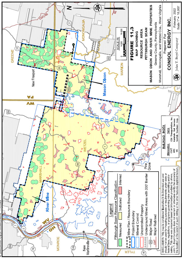
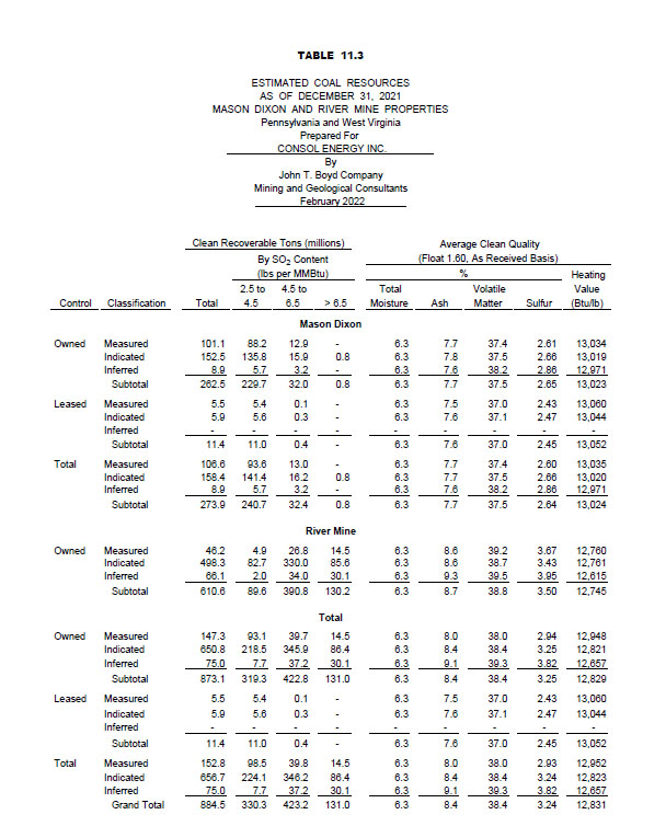
The reported coal resources include only coal which is reportedly owned or leased as of December 31, 2021. CONSOL owns 873.1 million clean recoverable tons, or 98.7% of the coal resources, with the remainder held under lease agreements.
The coal resources of the Mason Dixon and River Mine Properties are generally well‑explored and defined, with over 91% being reported in the combined measured and indicated categories. Given the uniformity of the Pittsburgh Seam in and around the properties, it is reasonable to assume that most inferred coal resources could be upgraded to indicated or measured resources with continued exploration and sampling; however, estimates of inferred coal resources have significant geological uncertainty and it should not be assumed that all or any part of an inferred coal resource will be converted to the measured or indicated categories.
Table 11.5 below summarizes the clean coal quality for the Mason Dixon and River Mine Properties. The reported coal resources generally consist of high-rank, high-volatile bituminous, medium-ash, and medium- to high-sulfur coal that may be used for thermal and limited metallurgical purposes.
|
Table 11.5: Estimated Coal Product Quality Summary |
||||||||||||||||||||
|
Average Clean Coal Quality (As Received Basis) |
||||||||||||||||||||
|
% |
Heating |
|||||||||||||||||||
|
Area |
Total Moisture |
Ash |
Volatile Matter |
Sulfur |
Value (Btu/lb) |
|||||||||||||||
|
Mason Dixon |
6.30 | 7.7 | 37.5 | 2.64 | 13,024 | |||||||||||||||
|
River Mine |
6.30 | 8.7 | 38.8 | 3.50 | 12,745 | |||||||||||||||
|
Average |
6.30 | 8.4 | 38.4 | 3.24 | 12,831 | |||||||||||||||
Figures 11.4 and 11.5 illustrate the clean coal ash and sulfur content over the Mason Dixon and River Mine Properties. As shown, there are slight increases in both ash and sulfur content from east to west across the properties. Approximately 85% of the reported coal resources are considered medium-sulfur or better coals.
Based on our review of CONSOL’s well-documented geologic modeling and estimation techniques, we are of the opinion that CONSOL’s resource estimation procedures are reasonable and appropriate. Furthermore, it is BOYD’s independent and professional opinion that the estimates of coal resources reported herein are suitable for public disclosure in compliance with SK-1300. The stated coal resources may be materially affected if mining, geological, economic, or regulatory factors change from those currently anticipated for the Mason Dixon and River Mine Properties. While many gas wells penetrate the Pittsburgh Seam coal bed throughout the
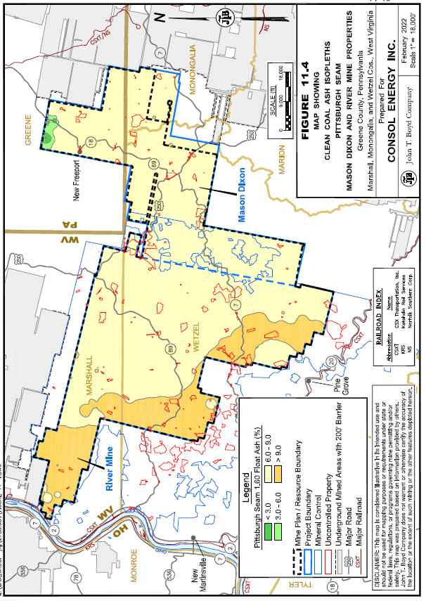
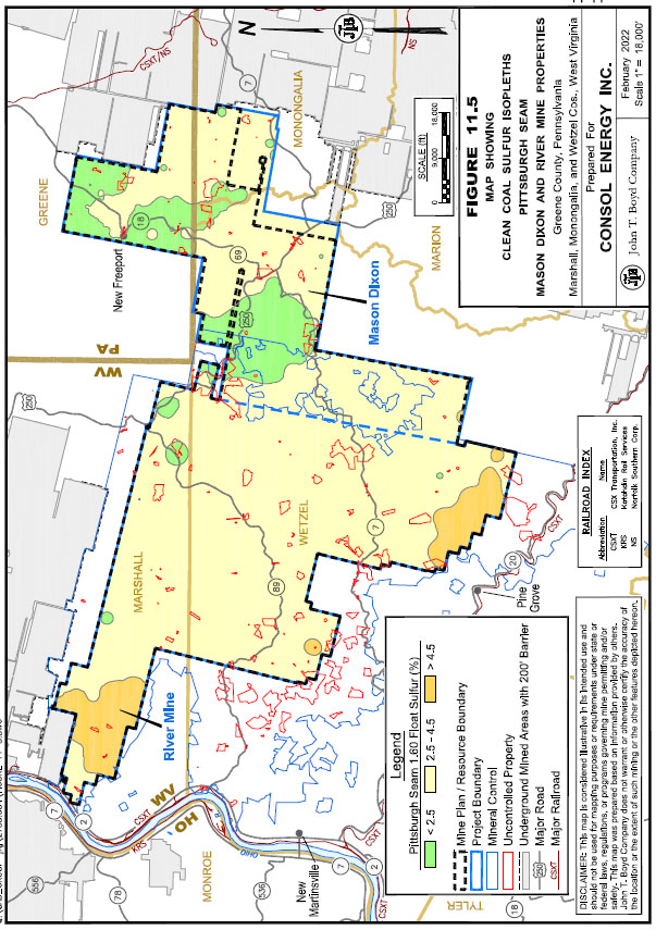
Mason Dixon and River Mine Properties, it is BOYD’s opinion that the presence of gas wells should not materially impact the reported coal resources.
12.0 COAL RESERVE ESTIMATE
12.1 Coal Reserves
Historical estimates[2] of “unassigned reserves” for the Mason Dixon and River Mine Properties totaled 903.4 million product tons as of December 31, 2021. Under previous disclosure rules, unassigned reserves represented coal which was not committed to production at an existing mining operation, and for which substantial capital investments were required to bring into production. While CONSOL has undertaken several technical and financial studies of the Properties, under current market conditions the coal resources do not have demonstrated economic viability. As such, there are no coal reserves for the Mason Dixon and River Mine Properties to report as of December 31, 2021.
13.0 MINING METHODS
There are no active or planned mining operations on the Mason Dixon and River Mine Properties. Conceptually, underground mining operations on the properties would utilize conventional LW methods for primary production. This mining method has proven highly successful at nearby Pittsburgh Seam mines, including CONSOL’s own Bailey, Enlow Fork, and Harvey mines.
14.0 PROCESSING OPERATIONS
There are no active or proposed coal preparation (or coal washing) operations on the Mason Dixon and River Mine Properties. Conceptually, coal preparation methods and operations would be similar to other operations producing coal from the Pittsburgh Seam.
15.0 MINE INFRASTRUCTURE
Numerous plans and engineering designs for both the River Mine and Mason Dixon Mine have been developed by CONSOL over the years, but no current plans have been presented or updated at this time.
16.0 MARKET STUDIES
There are no current marketing studies available for the Mason Dixon and River Mine Properties. Additional study is required before a declaration of coal reserves for the properties can be made.
17.0 PERMITTING AND COMPLIANCE
17.1 Permitting
Numerous permits are required by federal and state law for underground mining, coal preparation and related facilities, and other incidental activities. Typical of longer-term mining operations, new permits or permit revisions will most likely be necessary from time to time to facilitate future operations. Given sufficient time and planning, CONSOL should be able to secure new permits, as required, to maintain its planned operations within the context of the current regulations.
The stance of state and local governments towards coal mining has in many instances become much more restrictive as concerns relative to the societal and environmental impacts of coal mining have grown. As a result, the process of obtaining state permits for underground coal mining and other mine related activities in Pennsylvania and West Virginia has become more onerous over the past decade. The development of new or “greenfield” mining operations are expected to encounter long lead times due to the uncertainty of the permitting process and there is no certainty that desired permits will be issued.
CONSOL holds and maintains four mining permits with the state of West Virginia covering a deep mine, preparation plant, refuse disposal area, and fresh water impoundment for the Mason Dixon complex. Four associated NPDES permits are also held and maintained for these sites. Please refer to Section 3.3 for additional information.
17.2 Compliance
CONSOL reports having an extensive environmental management and compliance process designed to follow the ISO 14001 standard.
In their 2019 corporate sustainability report, CONSOL reports:
|
● |
99% compliance with internal sustainability goals. |
|
● |
Three years of annual decreases in agency-issued violations. |
|
● |
A year-on-year decrease in environmental penalty payments of which non-legacy violations were rated minor in severity. |
Based on our review of information provided by CONSOL, it is BOYD’s opinion that CONSOL has a generally typical coal industry record of compliance with applicable mining, water quality, and environmental regulations. BOYD is not aware of any regulatory violation or compliance issue which would materially impact the estimate of coal resources reported herein or preclude the reported measured and indicated resources from being converted to coal reserves.
17.3 Socio-Economic Impact
CONSOL states the following in their 2019 corporate sustainability report:
Equally important is the direct and indirect financial support we provide to the local economy—the communities where we operate, and our employees reside. This benefit extends to our service providers and business partners, whose employees live and work in the CONSOL operational areas of Pennsylvania, West Virginia, and Maryland. In 2018, our direct economic contribution of $401 million stemmed from employee wages, employee benefits, property taxes, income taxes, sales tax, and other taxes associated with production activities and paid to federal, state, and local governments. The Company’s total economic impact, including operating and capital expenditures, is approximately $1 billion annually.
BOYD is not aware of any community or stakeholder concerns, impacts, negotiations, or agreements which would materially impact the estimate of coal resources or preclude the reported measured and indicated resources from being converted to coal reserves.
18.0 CAPITAL AND OPERATING COSTS
CONSOL has performed capital and operating costs studies for the Mason Dixon and River Mine Properties in the past. At this time, there are no current capital and operating costs estimates for the Properties.
19.0 ECONOMIC ANALYSIS
CONSOL has performed economic analyses for the Mason Dixon and River Mine Properties in the past. At this time, there are no current economic analyses for the Properties. Coal resources, which are not coal reserves, do not have demonstrated economic viability.
20.0 ADJACENT PROPERTIES
A map (see Figure 1.1) of active and inactive Pittsburgh Seam underground mining operations located in proximity of the Mason Dixon and River Mine Properties indicates:
|
● |
In Greene County, Pennsylvania, the property is bounded by the reserve area controlled by Iron Senergy to the north and ACNR’s Monongalia County Mine to the east. |
|
● |
In Marshall County, West Virginia, the property is bounded by ACNR’s Marshall County Mine to the north and undeveloped property controlled by American Electric Power to the west. |
|
● |
In Wetzel County, West Virginia, the southern and western portion of the property is bounded by undeveloped coal reserves controlled by CONSOL (outside of the Mason Dixon and River Mine Properties area), while the eastern portion is bounded by ACNR’s Marion County and Harrison County mines. |
|
● |
In Monongalia County, West Virginia, the property is bounded to the east by the idled Federal No. 2 Mine and ACNR’s Marion County Mine. |
BOYD assumes CONSOL will include sufficient barrier zones to mitigate any risk associated with prior mining activities on adjacent properties as the Mason Dixon and River Mine Properties are developed.
21.0 OTHER RELEVANT DATA AND INFORMATION
BOYD is not aware of any additional information which would materially impact the coal resource estimates reported herein.
22.0 INTERPRETATION AND CONCLUSIONS
22.1 Audit Findings
BOYD’s independent technical audit was conducted in accordance with S-K 1300 and concludes:
|
● |
Sufficient data have been obtained through various exploration and sampling programs and mining operations to support the geological interpretations of seam structure, thickness, and quality for the portions of the Pittsburgh Seam situated within the bounds of the Mason Dixon and River Mine Properties. The data are of sufficient quantity and reliability to reasonably support the coal resource estimates presented in this technical report summary. |
|
● |
Estimates of coal resources reported herein are reasonably and appropriately supported by technical studies, which consider deposit geology and conceptual mining and processing methods. |
|
● |
The 884.5 million clean recoverable tons of potentially underground mineable coal resources on the property have reasonable prospects for the eventual economic extraction under assumed mining and economic conditions. |
|
● |
There is no other relevant data or information material to the Mason Dixon and River Mine Properties that is necessary to make this technical audit not misleading. |
22.2 Significant Risks and Uncertainties
A general assessment of risk is presented in the relevant sections of this report.
23.0 RECOMMENDATIONS
BOYD makes no recommendations regarding the Mason Dixon and River Mine Properties as there are no plans for their development at this time.
24.0 REFERENCES
There are no citations in this technical report summary. Therefore, there are no references to list.
25.0 RELIANCE ON INFORMATION PROVIDED BY REGISTRANT
In the preparation of this report BOYD has relied, without independent verification, upon information furnished by CONSOL with respect to property interests, exploration results, and historical production from such properties.
BOYD exercised due care in reviewing the information provided by CONSOL within the scope of our expertise and experience (which is in technical and financial mining issues) and concluded the data are valid and appropriate considering the status of the subject properties and the purpose for which this report was prepared. BOYD is not qualified to provide findings of a legal or accounting nature. We have no reason to believe that any material facts have been withheld, or that further analysis may reveal additional material information. However, the accuracy of the results and conclusions of this report are reliant on the accuracy of the information provided by CONSOL.
While we are not responsible for any material omissions in the information provided for use in this report, we do not disclaim responsibility for the disclosure of information contained herein which is within the realm of our expertise.
JOHN T. BOYD COMPANY